The next morning started out dreary and foggy. The Dingle Peninsula
was on our schedule for the day. John had climbed the first
hill before
The hill between Castlemaine and Tralee
at the eastern end of the Dingle Peninsula
and warned me that I would probably want to kill him for going
that way, and he was right. We went up and up and it got steeper
and steeper. At some point, he pulled off his gloves and handed
then to me. Then it got worse. I pleaded with John to take a
break. I couldn't call it a photo op, since we could barely
see a foot away
I had promised a nice view from the
top, but it wasn't to be as we headed up into low cloud. More
reasons for Pamela not to believe anything I said !
I thought about dropping his gloves, or at least saying I dropped
his gloves, but I was good and just kept pressing on, although
at some point, after I was sure my heart would give out if I
pushed any more, I did ease up just a bit.
We finally reached the top, and just as John had refused to
stop for me going up, I wouldn't stop for him. Although I finally
gave in, so I could zip my jacket, and John could get his gloves
back on. The descent was going to be slow. The road was rough
and there was no visibility. I wanted him to have warm comfortable
braking hands!
Pamela is really warm hearted !
 We
reached the bottom and eventually got on the scenic route to
Dingle. I nixed John's plan to go up another "Unsafe for
Horse Caravans Road" and insisted we stay on the scenic
route. I know he was really disappointed, but I needed a break,
and I didn't want to make him do most of the work again.
We
reached the bottom and eventually got on the scenic route to
Dingle. I nixed John's plan to go up another "Unsafe for
Horse Caravans Road" and insisted we stay on the scenic
route. I know he was really disappointed, but I needed a break,
and I didn't want to make him do most of the work again.
Dingle was closed when we arrived. We rode up and down
the main street in search of a lunch spot and couldn't find
anything open. I finally spotted a bakery and a restaurant off
in an alley. Despite finding a sign that said the restaurant
was open, we found locked doors at the top of the stairs. We
grabbed a few snacks at the bakery, but I was in serious need
of a bathroom and a warm place to eat. As we packed the deserts
into a pannier, a couple of local boys ran up the stairs to
the restaurant we had just tried. Upon finding the doors locked,
they surmised that the proprietors must be out to lunch! We
did eventually find another restaurant, where John had a mayonnaise
sandwich, with a little salmon on the side, and I had the crabmeat.
 It
was getting late and we still had the Connor pass to climb before
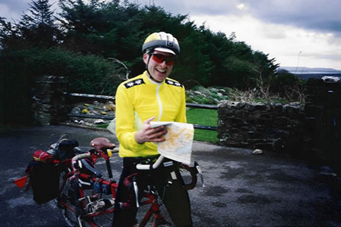
heading back up the Peninsula to Tralee. I looked at the Michelin
map and noticed red dotted lines next to the three climbs on
this peninsula. I looked at the key for a translation. It said
"dangerous and difficult road". Well, I'd been up
one of these, so now I was sure that Connor was going to be
a killer.
It
was getting late and we still had the Connor pass to climb before
heading back up the Peninsula to Tralee. I looked at the Michelin
map and noticed red dotted lines next to the three climbs on
this peninsula. I looked at the key for a translation. It said
"dangerous and difficult road". Well, I'd been up
one of these, so now I was sure that Connor was going to be
a killer.
Of course I tried to tell her otherwise,
that the Connor Pass is one of the best (or should I say, only)
graded climbs in the country, but Pamela still wouldn't believe
me.
I looked for the same dotted lines on some of the other climbs
we had taken, and there were none! So I was even more convinced.
Those red dotted markings aren't used
very often on the Michelin map and definitely not used on a
few roads where they should be. They aren't deserved on the
Conor Pass at all.
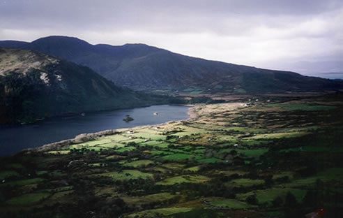
The weather reports the night before had mentioned strong winds
from the south. Fortunately we climbed south to north on this
pass. We stopped a couple of times to remove clothing as we
got warmer and warmer while climbing. I was a bit surprised
John let me stop, I sound kind of nasty,
don't I ??? but I think he was trying to make up for
the morning climb from Castlemaine.
To keep up with my reputation, I had
better just say I was getting mighty hot, and being the selfish
kind, I decided to stop and take off a few layers. It's just
a happy coincidence that the view was nice at the time !
I didn't realize how strong our tailwind was until I spit to
the side once and it landed a couple of meters in front of the
bike. With the tailwind, the climb didn't seem bad at all. So
maybe without a tailwind, the red dots are deserved, but it
really didn't seem any more difficult than many we had already
done. What was dangerous though was the wind. In retrospect,
we should have continued past the top to get out of the wind,
before stopping to add clothes, but we wanted pictures from
the top. Well the first thing that happened was the wind ripped
John's sunglasses from his hands. The lens went sailing down
into the valley, but I managed to grab the frames before they
went over. We tried to quickly add clothes, while not having
them blow away too, but it wasn't easy. A couple of pictures
and we were headed down, but not before surprising a couple
of tourists coming down from a hike, who insisted on getting
a picture of these two cyclists out in these awful conditions
- on top of this pass.
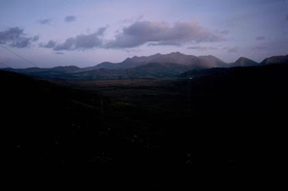 Darkness
came quickly once we were down off the pass. The lights went
on, but the moon provided illumination for much of the way.
There were a few clouds out and I watched as they quickly passed
across the moon. I watched and watched and found myself mesmerized
by this view. I'm sure John began to wonder if I was still back
there. I hardly said a word as I drank in the peaceful sight
of an almost full moon in a dark cloudy sky. The road was flat.
I didn't know flat roads existed in Ireland, but after a while,
I and my stoker weary butt wished for a few hills. I would occasionally
tap John as a signal to stand, but otherwise I watched the moon
and the ever closer lights of Tralee as we approached in the
early evening.
Darkness
came quickly once we were down off the pass. The lights went
on, but the moon provided illumination for much of the way.
There were a few clouds out and I watched as they quickly passed
across the moon. I watched and watched and found myself mesmerized
by this view. I'm sure John began to wonder if I was still back
there. I hardly said a word as I drank in the peaceful sight
of an almost full moon in a dark cloudy sky. The road was flat.
I didn't know flat roads existed in Ireland, but after a while,
I and my stoker weary butt wished for a few hills. I would occasionally
tap John as a signal to stand, but otherwise I watched the moon
and the ever closer lights of Tralee as we approached in the
early evening.
We found another wonderful guesthouse, and after showers went
out in search of Chinese food. We had a bit of an obstacle course
to get through at the door, but once in, we had another delicious
meal. Afterwards, we located the train station and found schedules
so we could plan our next day. We decided to take a train that
would get us close to Kilkenny, where I could see a castle and
do some shopping. We decided to go to Thurles, about 30 miles
away, a nice afternoon's ride.
y