 The
next morning, we discovered our map reading error, and headed
onto the town of Bantry, and then headed out the Beara Peninsula.
As we traveled along the coastal road, we hit quite a bit of
steep climbing. John had mentioned going over the little bump
called the Healy Pass, and I was starting to wonder how tough
it would be if I was already feeling drained. But I really wanted
John to enjoy himself on the trip and if he was willing to try
these passes, then I would definitely give it everything I had.
So we took the turn for the Healy Pass. Apparently, it's also
part of some big race over there too.
The
next morning, we discovered our map reading error, and headed
onto the town of Bantry, and then headed out the Beara Peninsula.
As we traveled along the coastal road, we hit quite a bit of
steep climbing. John had mentioned going over the little bump
called the Healy Pass, and I was starting to wonder how tough
it would be if I was already feeling drained. But I really wanted
John to enjoy himself on the trip and if he was willing to try
these passes, then I would definitely give it everything I had.
So we took the turn for the Healy Pass. Apparently, it's also
part of some big race over there too.
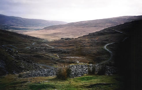
 I
was quite surprised that up to this point, we hadn't seen many
switchbacks. I decided that civil engineers in New England had
learned a lot about road building in Ireland. The roads were
like ours, straight up and straight down, although the Irish
roads were often a little bit twisty, but I hadn't seen anything
resembling a real switchback, until now. We turned and
climbed and turned 180 degrees and climbed, sometimes with a
tailwind, sometimes a headwind, sometimes with a view of the
ocean down below, others with a view of the crosses up above.
It really was an incredible view from the top. One thing about
climbing on clear days is you are rewarded with a view, as well
as the downhill. The downhill was the steep twisty kind, but
without the 180 degree switchbacks. We descended into a lovely
green valley, with ocean views on the far side.
I
was quite surprised that up to this point, we hadn't seen many
switchbacks. I decided that civil engineers in New England had
learned a lot about road building in Ireland. The roads were
like ours, straight up and straight down, although the Irish
roads were often a little bit twisty, but I hadn't seen anything
resembling a real switchback, until now. We turned and
climbed and turned 180 degrees and climbed, sometimes with a
tailwind, sometimes a headwind, sometimes with a view of the
ocean down below, others with a view of the crosses up above.
It really was an incredible view from the top. One thing about
climbing on clear days is you are rewarded with a view, as well
as the downhill. The downhill was the steep twisty kind, but
without the 180 degree switchbacks. We descended into a lovely
green valley, with ocean views on the far side.
 I
hadn't been up the Healy Pass before, but it definitely goes
down on my recommended list. I think it was also at its best
in the direction we went over it, from south to north.
I
hadn't been up the Healy Pass before, but it definitely goes
down on my recommended list. I think it was also at its best
in the direction we went over it, from south to north.
I believe we had planned to head down the Peninsula a bit further
to get another pass, but a wrong turn brought us into Kenmare,
where we had a lunch of smoked salmon and crab craws. While
John looked over the map, his eyes lit up as he talked about
all the nearby climbs. We decided to get a head start of tomorrow's
riding around the Ring of Kerry, by continuing onto Sneem. I
looked at the map, and offered John the reward of climbing Moll's
Gap to get there rather than taking the coastal (possibly flatter
route). Again his eyes lit up and we were off. Maybe
that light in my eyes was affecting my map-reading !
 Moll's
wasn't so tough, but it wasn't downhill all the way to
Sneem from there. We had at least one more little climb. Knowing
we would probably get in after dusk, I turned our taillight
on before heading out, and we definitely had the headlight on
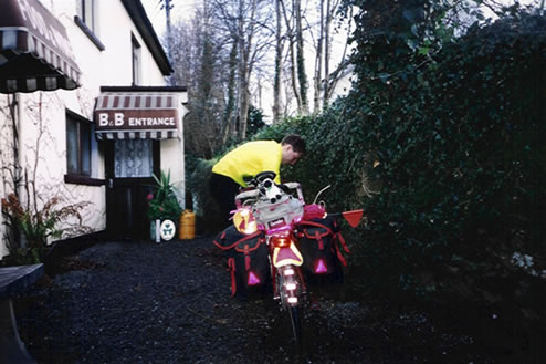
before arriving in town. In Sneem, we found a coffee and pastry
shop, with a B&B overhead. We grabbed a few pastries before
going up to our room for showers. We then walked back down to
a touristy sweater shop, where I picked up our mascot for the
rest of the trip, a little sheep who traveled on our trunk back,
checking out the scenery behind us.
Moll's
wasn't so tough, but it wasn't downhill all the way to
Sneem from there. We had at least one more little climb. Knowing
we would probably get in after dusk, I turned our taillight
on before heading out, and we definitely had the headlight on
before arriving in town. In Sneem, we found a coffee and pastry
shop, with a B&B overhead. We grabbed a few pastries before
going up to our room for showers. We then walked back down to
a touristy sweater shop, where I picked up our mascot for the
rest of the trip, a little sheep who traveled on our trunk back,
checking out the scenery behind us.
Our dinner in the only open bar in town was a very pleasant
surprise of salmon salad and crab salad. Being a Wednesday,
we bought lottery tickets, but we lost so we both have to return
to work !